
Page 15 - Demo
P. 15
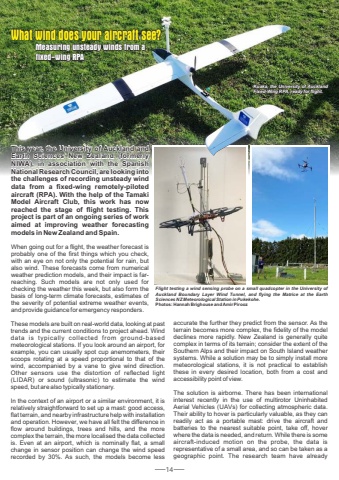
14What wind does your aircraft see? Measuring unsteady winds from a fixed-wing RPAKuaka, the University of Auckland Fixed-W Fixed-Wing RPA, ready for flight.Kuaka, the University of Auckland Fixed-Wing RPA, ready for flight.This year, the University University of Auckland Auckland and Earth Sciences New Zealand (formerly NIWA), in association association with the Spanish Spanish National National Research Research Council, Council, are looking looking into the challenges challenges of recording recording unsteady unsteady wind data from a fixed-wing remotely-piloted aircraft aircraft (RPA). With the help of the Tamaki Model Aircraft Aircraft Club, this work has now reached reached the stage of flight testing. testing. This project project is part of an ongoing ongoing series of work aimed at improving weather forecasting models in New Zealand Zealand and Spain.This year, the University of Auckland and Earth Sciences New Zealand (formerly NIWA), in association with the Spanish National Research Council, are looking into the challenges of recording unsteady wind data from a fixed-wing remotely-piloted aircraft (RPA). With the help of the Tamaki Model Aircraft Club, this work has now reached the stage of flight testing. This project is part of an ongoing series of work aimed at improving weather forecasting models in New Zealand and Spain.When going out for a flight, the weather forecast is probably one of the first things which you check, with an eye on not only the potential for rain, but also wind. These forecasts come from numerical weather prediction models, and their impact is farreaching. Such models are not only used for checking the weather this week, but also form the basis of long-term climate forecasts, estimates of the severity of potential extreme weather events, and provide guidance for emergency responders.These models are built on real-world data, looking at past trends and the current conditions to project ahead. Wind data is typically collected from ground-based meteorological stations. If you look around an airport, for example, you can usually spot cup anemometers, their scoops rotating at a speed proportional to that of the wind, accompanied by a vane to give wind direction. Other sensors use the distortion of reflected light (LIDAR) or sound (ultrasonic) to estimate the wind speed, but are also typically stationary.In the context of an airport or a similar environment, it is relatively straightforward to set up a mast: good access, flat terrain, and nearby infrastructure help with installation and operation. However, we have all felt the difference in flow around buildings, trees and hills, and the more complex the terrain, the more localised the data collected is. Even at an airport, which is nominally flat, a small change in sensor position can change the wind speed recorded by 30%. As such, the models become less accurate the further they predict from the sensor. As the terrain becomes more complex, the fidelity of the model declines more rapidly. New Zealand is generally quite complex in terms of its terrain; consider the extent of the Southern Alps and their impact on South Island weather systems. While a solution may be to simply install more meteorological stations, it is not practical to establish these in every desired location, both from a cost and accessibility point of view.The solution is airborne. There has been international interest recently in the use of multirotor Uninhabited Aerial Vehicles (UAVs) for collecting atmospheric data. Their ability to hover is particularly valuable, as they can readily act as a portable mast: drive the aircraft and batteries to the nearest suitable point, take off, hover where the data is needed, and return. While there is some aircraft-induced motion on the probe, the data is representative of a small area, and so can be taken as a geographic point. The research team have already Flight testing a wind sensing probe on a small quadcopter in the University of Auckland Boundary Layer Wind Tunnel, and flying the Matrice at the Earth Sciences NZ Meteorological Station in Pukekohe. Photos: Hannah Brighouse and Amir Pirooz
